
Satellite Analysis in Your Browser. No GIS Software Needed.
Analyze 40 years of Landsat and Sentinel-2 imagery instantly. NDVI, time series, mosaics, and AI change detection — all from your browser.
Try TerraView Free →No credit card required. Start analyzing in 30 seconds.
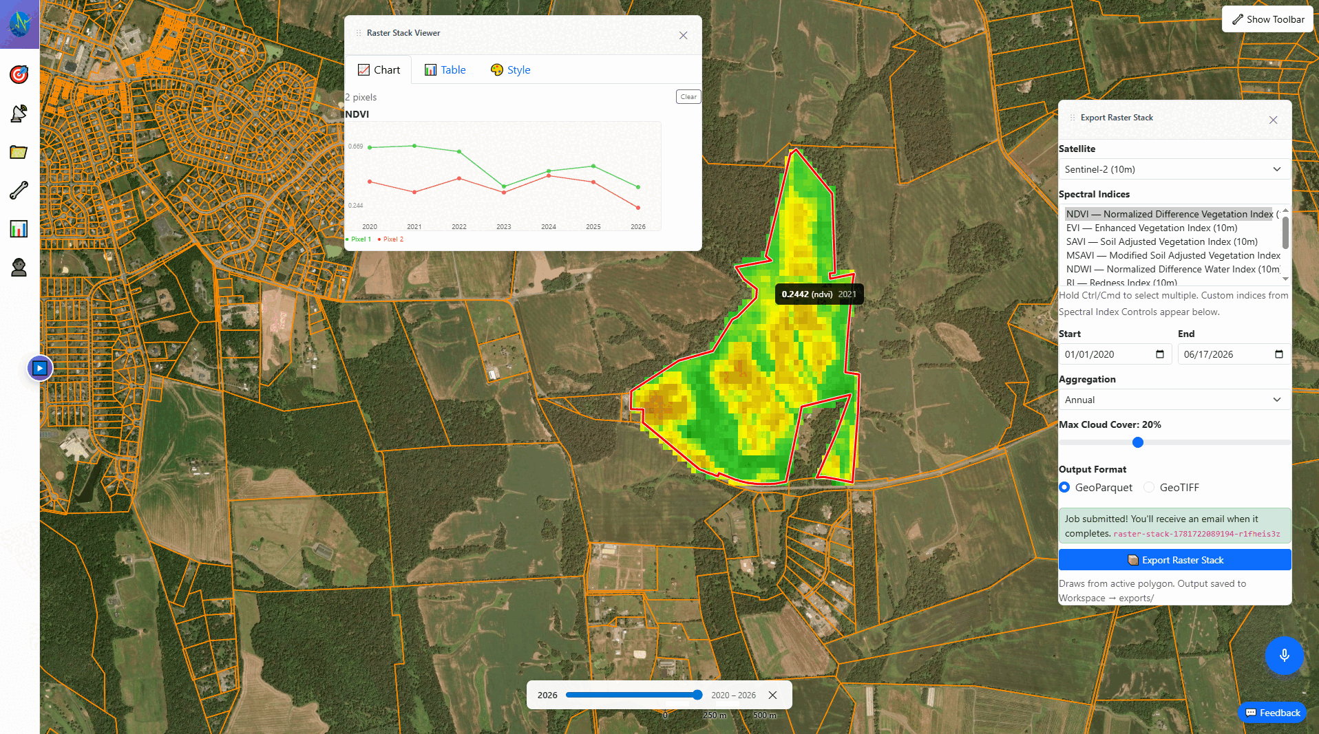
Results in 30 Seconds
No installs, no configuration, no learning curve. Draw, query, analyze.
Draw Your Area
Click on the map to draw a polygon around any area on Earth — a farm, a forest, a city.
Choose Your Analysis
Select spectral indices (NDVI, EVI, NBR...), date range, and satellite (Landsat or Sentinel-2).
Get Results Instantly
View time series charts, color-mapped imagery, and statistics. Export to CSV or GeoTIFF.
Everything You Need for Satellite Analysis
Professional-grade remote sensing tools, accessible to everyone.
Millions of Satellite Imagery
Complete Landsat archive (1984–present) and Sentinel-2 (2017–present, 10m resolution). Updated continuously.
Time Series Analysis
Multi-index vegetation and temperature trends with dual-axis charts. Weekly, monthly, or annual aggregation.
20+ Spectral Indices
NDVI, EVI, SAVI, NDWI, NDBI, NBR, MSAVI2, and more. Instant computation from raw satellite bands.
AI Change Detection
Detect deforestation, burn scars, floods, and crop changes using NASA's Prithvi foundation model.
Multi-Scene Mosaics
Combine multiple satellite scenes into seamless cloud-free composites. RGB, false color, or any spectral index.
Cloud Workspace
Save analyses, GeoTIFFs, and color schemes to your workspace. Access from any device, export anytime.
Surface Temperature
Analyze thermal infrared data from Landsat. Track surface temperature trends alongside vegetation indices.
Parcel Boundaries
Overlay property boundaries for 16 US states. Identify parcels and clip analyses to ownership lines.
Mobile Ready
Full analysis capabilities on your phone or tablet. Check field conditions, run queries, and view results from anywhere. Install as a native app on desktop or mobile.
Built for Professionals Who Need Answers Fast
No coding, no complex workflows. Just results.
Agriculture
Monitor crop health across all your fields. Track NDVI trends through the growing season. Detect stress early.
Forestry
Track canopy health, post-harvest regrowth, and carbon stock changes across your entire portfolio.
Environment
40 years of data for EIA reports. Monitor deforestation, wetland loss, and land-use change over decades.
Research
Instant access to Landsat + Sentinel-2 with CSV export. No downloads, no preprocessing. Focus on your analysis.
How TerraView Compares
Get results in seconds instead of hours.
| Feature | TerraView | Google Earth Engine | QGIS |
|---|---|---|---|
| Setup time | Instant | Days (approval) | Hours |
| Coding required | None | JavaScript/Python | Some |
| Landsat + Sentinel-2 | Built-in (millions of scenes) | Built-in | Manual download |
| Time series | Point and click | Code required | Plugin |
| AI change detection | Built-in | Code required | Plugin |
| Spectral indices | 20+ built-in | Code required | Plugin |
| Starting price | Free / $29/mo | Free (research) / Usage-based | Free |
Simple, Transparent Pricing
Start free. Upgrade when you need more.
Professional
- 100 GB storage
- 10-year archive
- 5,000 hectares
- 500 analyses/month
- AI change detection
Enterprise
- 1 TB storage
- Complete archive (1984+)
- 50,000 hectares
- 2,000 analyses/month
- Priority support
Save 20% with annual billing. All plans include soft overage billing — never blocked mid-analysis.
Start Analyzing Satellite Data in 30 Seconds
Free forever. No credit card. No downloads. Just draw a polygon and see results.
Try TerraView Free →